Michel Solien of Sheboygan, Wisconsin sought three exemptions from the Hubbard County Shoreland Management Ordinance for his proposed 41-site RV park on Pickerel Lake.
After nearly 1.5 hours of discussion, the Hubbard County Planning Commission approved three variance requests for a proposed recreational vehicle (RV) park on Pickerel Lake.
At one point, the audience responded with a chorus of boos.
Michel Solien of Sheboygan, Wisconsin sought three exemptions from the Hubbard County Shoreland Management Ordinance (SMO) for his proposed 41-site RV park, permanent rental cabin and owner’s residence.
Called Decision Hills Campground, it would be located at 25848 Holly Road on 26.5 acres.
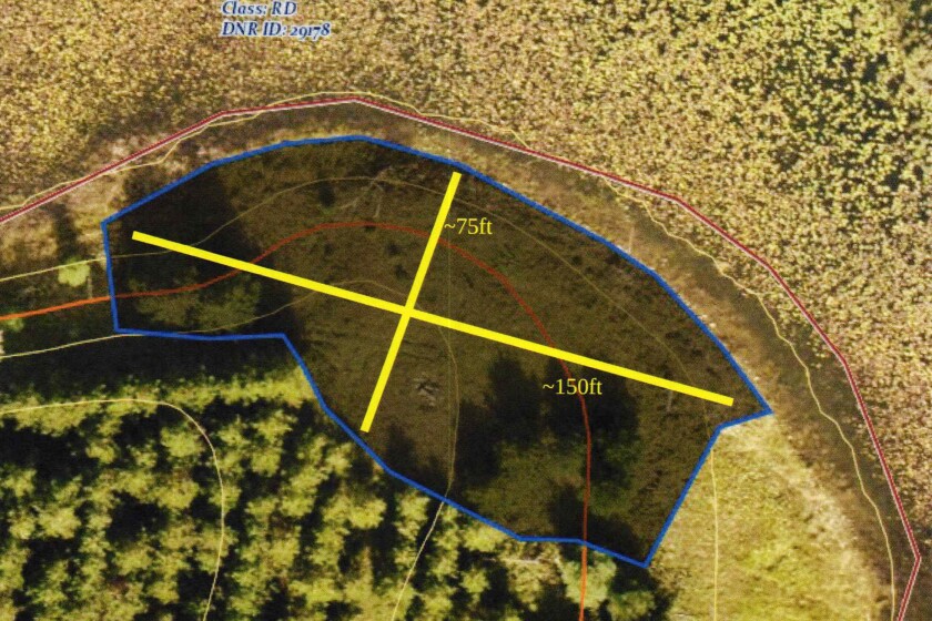
Pickerel Lake, located off CSAH 4 in Lake Emma Township, is 310 acres, according to the Minnesota Department of Natural Resources.
Solien’s requests were the last agenda item of the evening. The meeting concluded about 10 p.m. on Monday, Oct. 24.
With its approval of the variances, the planning commission added the condition that they are only valid if a conditional use permit (CUP) is acquired.
Environmental Services Office (ESO) staff recommended the condition, saying this “guards against any or all of these items being acted upon in the event the proposed CUP application is either not submitted or approved.”
ESO staff also recommended the condition that the grading work and campground layout must be done according to the various site plan surveys, sketches and cross-section elevation drawings included in the application.
In August, the planning commission approved septic system variances for this project.
Solien wants to establish a 150-foot-by-75-foot swimming, picnic, boating area for campground guests and his family.
A second recreation area would be created at the north end of the property.
According to the ESO staff report, “having two locations on opposite ends of the property for campground guests to use to view and access the lake would be in harmony with the ordinance’s intent of allowing a 20-foot-by-15-foot recreation area on a standard 150-foot residential lot. That would result in at least roughly eight to nine such areas being allowed, if the property was subdivided into residential lots.”
Commissioners Ken Grob and Mike Kovacovich took issue with the size of the waterfront area.
Grob pointed out there’s “a lot of concern” from local residents about this complex project “because it’s a somewhat small, sensitive lake.”
“The way you’ve laid out that recreation area is very inconsistent with what would be allowed with a residential property,” Grob continued, which is 20-by-15-foot and no vegetation removal within the first 50 feet of the shore impact zone.
These requirements are in place for protection of the lake, Grob said, “because science says that’s what you need to prevent runoff and degradation to the lake.”
Grob said he was “uncomfortable” with Solien’s request, along with the lack of detailed plans about vegetation removal, grading and other alterations.
“Why should we allow a campground on a sensitive lake to have far more potential runoff than if it were riparian lots? That’s my issue,” he said. “I don’t know how to get around it.”
Solien said he envisions a mowed lawn down to the shoreline.
Kovacovich agreed with Grob, suggesting the area should be considerably smaller and should include a 50-foot no-mow buffer. He noted that a residential lot is allowed 300 square feet, but Solien’s request is for 11,250 square feet – the equivalent of 37.5 residential lots.
Pointing to the fact that the request is only for 150 feet of a 1,550 feet of shoreline, commissioners Mark Petersen, Tim Johnson and Veronica Andres favored approving the variance.
It’s not a residential lot, so can’t be treated as one, they said, plus the area is already a naturally open grass prairie.
The ESO staff report states the second recreation area would be “on a small upland area located in the northwest corner of the property along Holly Road. Due to the wetland that lies south of this area, a question to ask the applicant would be how campground guests would physically access this area from the campground. It appears that guests would need to walk/drive on Holly Road or walk alongside the road in the ditch in order to reach it from the campground.”
Solien said there were no plans to make a parking lot.
Planning commissioners had no complaints about Solien’s proposed permissible volume of grading/fill or exceeding an impervious surface rule.
The staff report states the SMO allows 10 cubic yards of material to be moved per project by permit in steep slopes per 150 feet of shoreline. In this case, that would be roughly 103.3 cubic yards.
Solien’s application says that approximately 8,672 cubic yards of material will be cut and 3,185 cubic yards of fill in steep slope areas.
Additional grading work to create campground sites and access roads are beyond the 100-foot ordinary high water mark (OHW) structure setback, the staff report said, so would not be regulated by the SMO.
Solien estimated 200 or so trees would be removed as well.
While the overall project is below the 25% impervious surface area threshold, Solien said Tier 2 (a 267- to 534-foot OHW setback) exceeds it by 3.4%.
Holly Road, a Lake Emma Township road, accounts for 1.9% of this impervious surface area, according to Solien’s application.
ESO staff wrote most of the impervious surface area is located in the interior of the property “that is well screened from the lake by a 200-plus-feet of deep mature Norway pine plantation and other mature forest cover.”
In order to reduce impervious surface, Solien said he would cut eight sites from his original 47-site design – three from Tier 2 and five from Tier 3 – but the commission counted 41 sites total. ESO Director Eric Buitenwerf explained there is some overlap between these tiers.
The planning commission unanimously approved these two variances.
Seventeen letters voiced opposition to the variances. Four spoke publicly at Monday’s meeting.
Curt Soehl described the waterfront recreation area as “an enormous playground.”
“That’s all muck all the way out. There’s just lily pads,” he said, along with a spot where crappies spawn in the springtime. “It’s 5 feet of water 100 feet out.”
Soehl asked the commission to scale back the volume of fill as well.
Jeffy Dubay said he was “vehemently against any variance.” He pointed out that he can’t mow down to his shore.
According to Dubay, this is the fourth attempt from a developer to create a park. “The previous three times the board has seen fit to deny it going in because it just doesn’t make sense.”
Cliff Tweedale, president of the Blue Lake Association, wrote that they are closely following this project. Given the development’s close proximity to the Blue Lake public access, Tweedale said the association’s main concern is the potential for increased watercraft activity on both lakes.